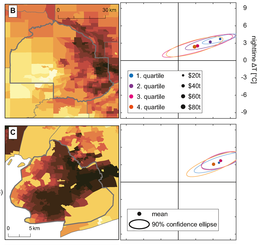
Remotely sensed land surface temperature measurements are used to explore the distribution of the United States’ urban heating burden. Drawing on urban temperature anomalies during extreme summer surface temperature events from all 1,056 US counties with more than 10 developed census tracts, we find that the poorest tracts (and those with lowest average education levels) within a county are significantly hotter than the richest (and more educated) neighborhoods for 76% of these counties (54% for education); we also find that neighborhoods with higher Black, Hispanic, and Asian population shares are hotter than the more White, non-Hispanic areas in each county.


