

Paraguayan Rural Youth Face Barriers to Educational Access
Mapping the spatial relationship of schools to secondary school-aged youth in Paraguay points to students in rural communities as the most distanced from schools
Although Paraguay has made significant progress in expanding educational opportunities for youth, they still have much headway to make in SDG 4: Promoting a Quality Education. As of 2012, lower, secondary education had a 73% completion rate and by 2015, six out of ten youth, did not complete secondary education. These low levels of completion rates are concerning. As Paraguay considers future strategies to improve educational outcomes, it must prioritize not only completion rates for secondary education, but youth in rural communities, who still face persistent barriers to educational access.
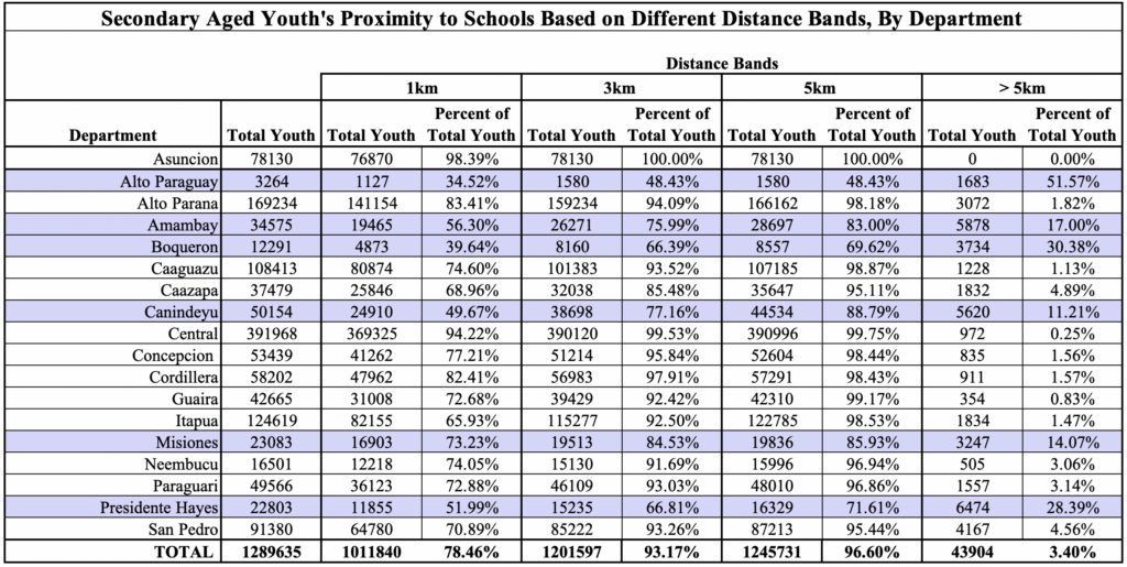
Based on 2020 youth population projections and 2016 school locations, I use a geospatial analysis to understand the relationship between school distribution and student reach. I find that 97% of secondary-aged youth in Paraguay are located at least five kilometers away from schools. However, when you break this down sub nationally, six of the seventeen departments (the Paraguayan equivalent of states in the US) in Paraguay, face considerable barriers to schools that are proximate to youth. Departments that have at least ten percent of youth not in a five kilometer radius to schools include: Alto Paraguay, Amambay, Boqueron, Canindeyu, Misiones, and Presidente Hayes. Alto Paraguay faces the highest proportion of students not at least five kilometers from a school, with 50% of youth not being near a school under five kilometers. Overall, youth in these departments are not in close proximity to schools, which potentially compounds the challenges they already face to educational access.
Why distance to school? At a most basic level, distance to school serves as a proxy for educational access. Proximity to a school is an important geospatial measure that helps us understand the relationship between public schools and the communities they serve. Consider the distance of one kilometer from a local school. If you do not have a car or public transit at your disposal, it might take about ten to twelve minutes to walk. On average, it takes about 30 minutes to walk three kilometers, and about forty-five minutes to an hour to walk five kilometers. The closer a family is to a school, the more accessible a school is. This has implications for attendance, completions rates, a safe space for students to be in, and a source of community. Additionally, proximity to a school also has implications for transportation and travel time for youth.
With distance and proximity to schools as a key measurement, I calculate the number of youth serviced by schools at three different distance bands: one kilometer, three-kilometer, and five-kilometer. Each distance band provides a radius for distinct buffer zones. Although past research does not expand on an ideal distance a student should be from a school, I consider three kilometers as both a walkable distance and close enough to use other methods of transportation if available. Five kilometers is considered as an upper limit. Anything farther than five kilometers would be less accessible by foot.
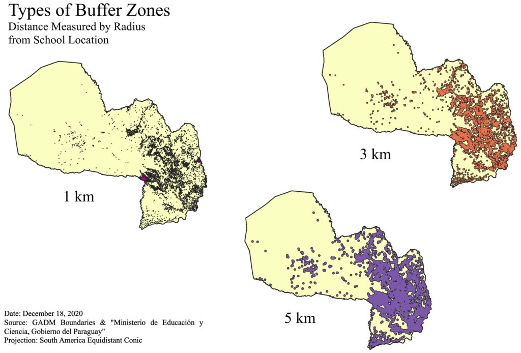
Table 1 provides an in-depth breakdown of the number of youth covered by these different buffer zones defined by the three different distance bands. The greatest youth coverage happens when we go from one kilometer to three kilometer radius: there is a thirteen percentage point change in the number of youth reached, compared to only three percentage points when going from a three kilometer to a five kilometer radius. Overall, results demonstrate a parallel with the location of a school to how urban or rural an area is. For example, in Asuncion, the country’s capital, Asunción’s secondary-aged youth are all located at least three kilometers from a school, although 98% are at one kilometer from schools, representing a high percentage of youth proximate to schools.
Future geospatial analysis can also consider gendered differences to school proximity, transportation infrastructure that supports school attendance, in addition to other indicators of educational quality such as the quality of schools, teachers’ availability, and classroom resources. On top of these factors, Paraguay must consider the negative impacts of COVID-19 on student learning.
As Paraguay plans to meet SDGsfor 2030, it must prioritize educational access and ask: are schools close enough to students? As seen in this analysis, proximity to schools is an important first step that defines educational access, especially in rural communities.