Land Use Policy for a More Sustainable San Diego
Local policymakers looking to address local goals of increasing housing and congestion while also achieving the SDGs can prioritize land use in the area surrounding light rail stations in San Diego
As the urgency to address climate change increases at the global level, pressure is building to reduce greenhouse gas (GHG) emissions from transportation at the local level, which accounts for 23% of energy-related emissions globally and 54% of GHG emissions locally. In addition to taking action on climate (SDG 13), access to “sustainable transport systems” is identified as a target in SDG 11, sustainable cities and communities. In San Diego, planning departments at the City, County, and SANDAG, have identified housing density near transit, or Transit-Oriented Development (TOD), as a policy priority that can increase environmental sustainability while supporting economic growth. TOD can shift commutes from automobiles to public transportation while addressing the high cost of housing through an increase in supply. Demand for TOD housing units in San Diego was found to be 1.3 times greater than for units without access to transit but development has been largely constrained by land use regulations. If policymakers can address these constraints, TOD can meet housing demand while making progress on local and global goals. The question facing policymakers in San Diego is which transit stations should be prioritized for TOD?
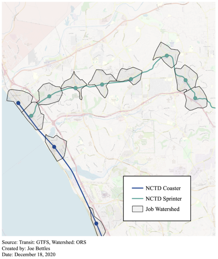
Geospatial methods that build on work in Columbus, Ohio offer insights that can be used by local policymakers to prioritize TOD. To identify priority transit areas, this analysis looks for underutilized land around rail stations that is characterized by restrictive land use regulations while having a high number of accessible jobs. I focus on rail stations because people tend to choose rail over buses due to a preference for public transportation that is “fast, frequent and reliable”, as well as a psychological preference for rail. I combine NCTD commuter rail stations and the MTS Trolley (including the Blue Line extension to UCSD, expected to open in 2021) to calculate job density at each rail station in San Diego. I use Census data to find the number of jobs in a “watershed”, or the area within a 15-minute walking distance to the station, shown in Figure 1 around NCTD stops in North County. I calculate the total accessible jobs for each station as the sum of all jobs within 30 minutes transit time (including a 7.5-minute average wait at the station) and a 15-minute walk at each end.
Higher demand for housing around transit in San Diego would suggest high zoning scores, particularly for stations with a high number of accessible jobs. However, a 2015 report identified San Diego as having some of the lowest densities around transit in California. I test this finding through a comparison of job accessibility and zoning to see if stations are underutilized due to land use restrictions.
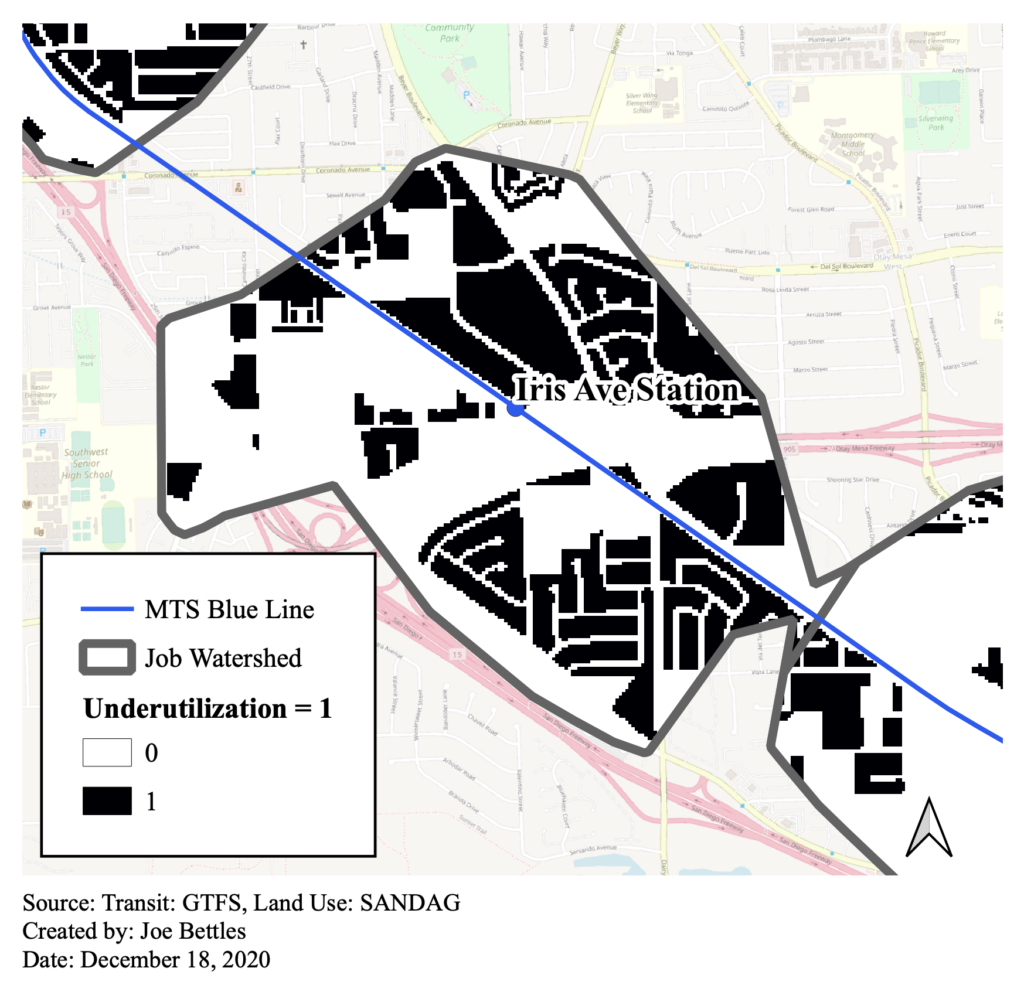
In order to understand which stations in San Diego are the most underutilized in terms of residential and commercial zoning as compared to job accessibility, I assign each station a zoning score which indicates the percentage of land within a 15-minute walk that has zoning unsuitable for TOD. Underutilized land includes zoning for warehouses, parking (excluding park-and-ride), industrial, and single-family-home. Utilized land by contrast includes zoning for commercial, mixed-use, and multi-family residential in medium to high densities. The zoning score is shown in Figure 2 for the land surrounding the Iris Station near the Otay Mesa border crossing.
In order to find overall underutilization according to accessible jobs and zoning, I multiply a standardized job score and the percentage underutilized to create an ordered list of the ten most underutilized and utilized stations, shown in Tables 1 and 2.
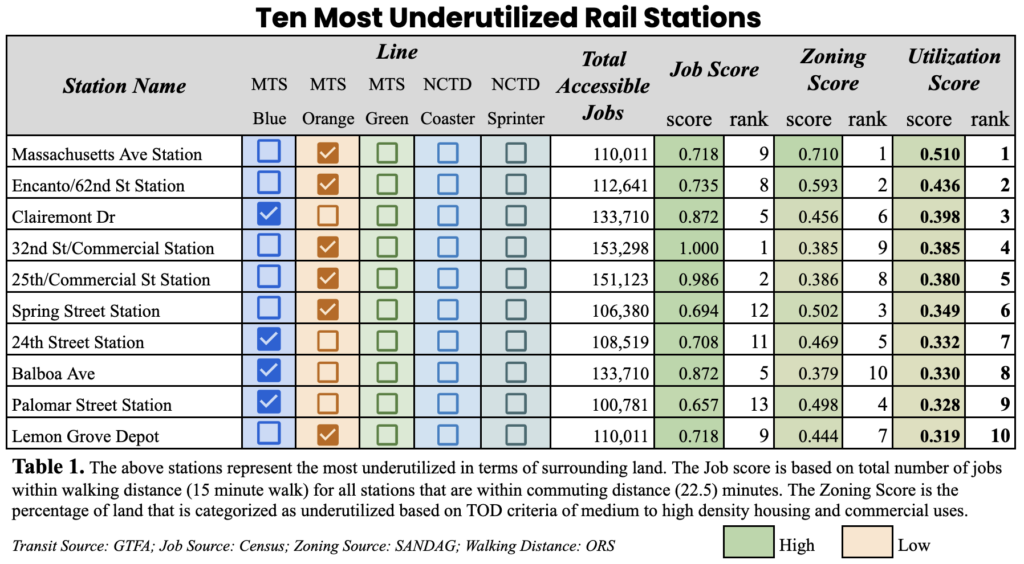
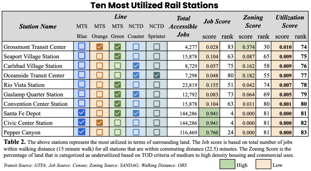
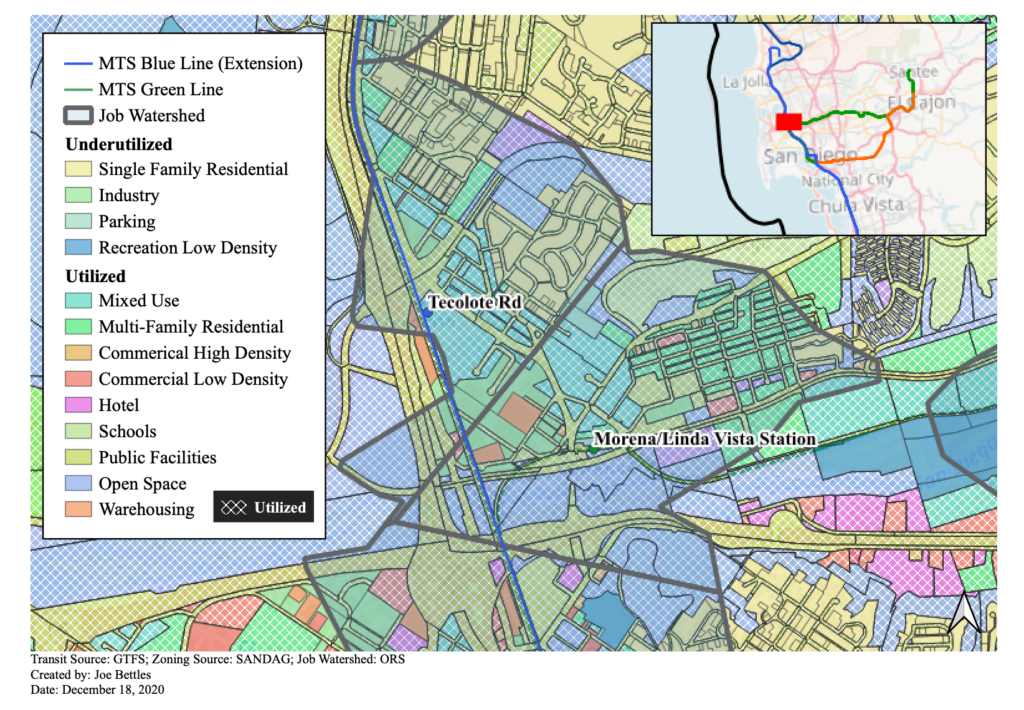
Contrary to expectations that high job accessibility would be associated with higher zoning densities, Table 1 shows that many of the stations with the most number of accessible jobs also have the least amount of land dedicated to commercial and residential uses at medium to high densities. The most underutilized station, the Massachusetts Ave Station (Fig 3), is located 6 stations away from both the Downtown San Diego 12th and Imperial Transit Center and the Downtown El Cajon Transit Center, two major employment centers in San Diego. Despite high job accessibility, the area surrounding the station is dominated by single-family-home zoning. In contrast, Morena/Linda Vista Station on the Blue Line Extension, shown in Figure 4, ranks as the 13th most utilized and is an example of a station surrounded by a variety of land uses suitable to transit including commercial, mixed-use, and multi-family residential. However, one station to the north on the Blue Line Extension, Tecolote Rd (also shown in Fig 4) is dominated by single-family-home zoning and ranks as the 15th most underutilized station. With downtown and UC San Diego within commuting distance, Tecolote Rd should be considered as a priority for TOD.
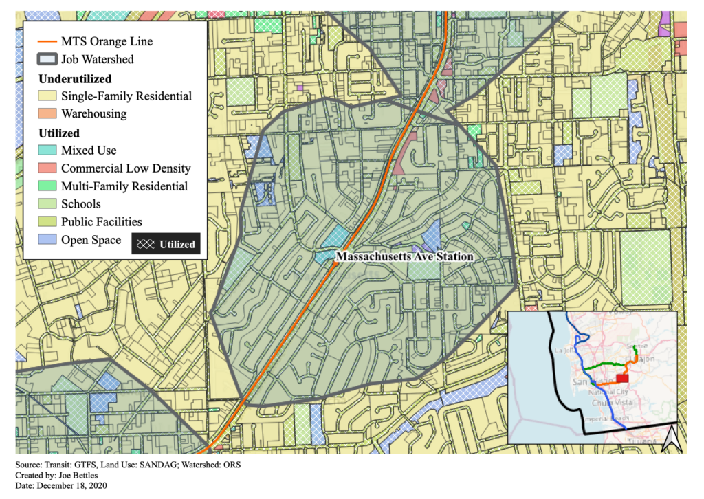
In addition to zoning regulations, the analysis tells a story of disinvestment. According to the 2010 Census, 61% of residents in the zip code around the Massachusetts Ave Station are below the poverty line. Addressing the need for redevelopment in low-density and low-resource neighborhoods requires a different set of policies and a greater need for redistribution. Policymakers can use the benefits captured from increasing the value of land to invest resources in surrounding communities and ensure that residents are not displaced by redevelopment.
Despite higher demands for housing near rail, the areas surrounding stations in San Diego are found to lack densities suitable for TOD. The findings suggest that opportunities exist for policymakers to increase the supply of housing without increasing congestion. This effort can also fulfill global commitments to SDG 11 and SDG 13 and contribute to a more sustainable city for all.

